
My Map to Immersion
By Vaughn Roycroft | November 19, 2018 |
 I’ve always loved maps. My earliest memories of map-reading are from family car-trips. My dad would reach into the (gigantic!) glove compartment of our ’68 Chevy Bel Air, and hand back the newest neatly folded roadmap of Michigan from his (gigantic!) pile of maps to my sister and me (hey, anything that quiets backseat rowdiness). He religiously picked up the AAA’s latest version from his insurance agent, whose office was a stone’s throw from his barbershop. (In his defense, those were days of growth for American infrastructure.)
My sister and I would pore over the map, pointing out the odd town names of the Mighty Mitten, and giggling over the absurd trips one could make between them: from Bellevue to Belleville (in our Bel Air!); Pontiac to Cadillac; Bad Axe to Hell; Podunk to Jugville; and even Colon to Climax (a very pleasant 30 minute ride, I swear).
Beyond the giggles, I found it all enthralling. I mean, let’s face it, Michigan has an alluring shape. Not to mention her 3,288 miles of shoreline (second only to Alaska). I remember studying the coasts, the islands, and the towns at the extreme tips of peninsulas—places like Northport, Mackinac, Copper Harbor, and Whitefish Point, and wondering how it would feel there—to be surrounded by nothing but water and forest. I’ve since been to most of the places I wondered about. And though a rare few failed to live up to the expectations of youth, most have exceeded them, and several have become favorite getaways.
My love of maps has undoubtedly contributed to my enduring love of my home state. But I can see that my love of maps also provided a natural lead-in to my love of reading.
And I’ve also become convinced that a line can be drawn from my love of maps to my current life as a writer. Allow me to diagram my case.
A Tolkien of My Affection
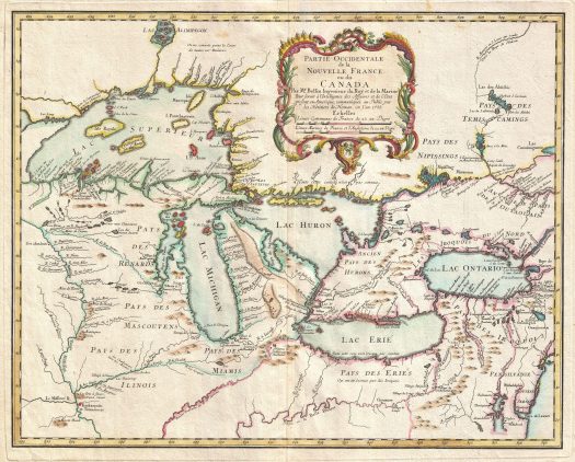
As some of you may know, I write epic fantasy, and cite Tolkien as a guiding star among the constellation of my inspirations. Before reading Tolkien, I’d been captivated by a middle-grade book by Dirk Gringhuis called The Young Voyageur. My parents bought it for me in the gift shop of the restored Fort Mackinac, on Mackinac Island (one of those intriguing map dots I mention above). The entire inside cover of the book is a map of the Great Lakes, marked with all of the French and British forts along the shores, and charting the protagonist Danny’s travels, covering hundreds of miles of shoreline and rivers… in a canoe!
Many of the places Danny found himself were places I had visited (thank you, history-buff parents). As I read I found myself referring to the map often. I also remember going to our family encyclopedias to look up French Voyageurs (thank you, “go-look-it-up-yourself, kid” parents). And I clearly recall finding an image of an early French map of the Great Lakes much like the one at the top of this post. I was predictably fascinated, trying to reconcile rivers and landmarks, marveling over how it might have been drawn at the time that it was. All of which put me right into Danny’s shoes.
I’m not sure how long it was after reading The Young Voyageur that I discovered Tolkien (thanks, Mr. Raymond!), but not more than a couple of years. I remember stumbling upon the map at the front of The Hobbit before I started it, and loving the tiny trees of Mirkwood and the drawings of the Misty Mountains. Closer study revealed the tiny dragon drawn above the Lonely Mountain and the spiders embedded in the forest. Then there was that heavy line from top to bottom demarking, “The Edge of the Wild.” Whoa.
There was so much to be gleaned. Which only served to fuel my fervor for the story.
The whole process started over again with The Lord of the Rings boxed set, except this time I didn’t need to stumble upon the map. I immediately sought it out, and was delighted to find the map expanded to reveal Middle Earth in its glorious entirety. It was an enticing indication of how far the story would expand, and I endlessly dissected it, referring to it almost comically often as I read.
Undeniably Tolkien’s maps played a role in pointing me down the storytelling path.
Connecting the Dots
Though I’ve always loved them, lately maps have been even more on my mind than usual. It started with WU’s own Tom Bentley, who’d come across an excellent essay on books with maps by Sarah Laskow. Tom rightly surmised that I’d be of the map-geek persuasion, and kindly passed it along. A few days later a dear friend reached out to me with a question about my latest manuscript, which she is kindly beta-reading. The question was about the locations of two port cities. Her confusion was understandable, but it made me realize that a glance at a map would’ve easily answered it. But I hadn’t provided one.
Over a decade ago I read a piece by fantasist Joe Abercrombie about why he hadn’t included a map for his debut, in which he says, “I want a reader to be nailed to the text… not constantly flipping back to the fly-leaf to check just how far Carleon is from Uffrith, or whatever. The characters often don’t know what’s going on. If they don’t have a conveniently accurate map to hand, why should the reader?”
Abercrombie’s piece contends that our stories should be compelling and self-explanatory without visual aids. Plus, not being trained cartographers (Joe and I and most other writers), our efforts can potentially open us to a level of scrutiny that’s often irrelevant to the story. At the time of reading it, I’d already tried my hand at mapmaking. Extensively. And in my less than stellar results I immediately saw his point. Besides, agents and editors to whom we submit will consider no such supplement.
I determined then that, in spite of my love of maps, the story would have to stand on its own. And I simply stopped drawing them.
Finding the Way Back to Maps
“One of life’s great treats, for a lover of books (especially fantasy books), is to open a cover to find a map secreted inside and filled with the details of a land about to be discovered. A writer’s map hints at a fully imagined world, and at the beginning of a book, it’s a promise. In the middle of a book, it’s a touchstone and a guide. And at the end, it’s a reminder of all the places the story has taken you.”—Sarah Laskow, from her essay, How Writers Map Their Imaginary Worlds
In the interest of full disclosure, there have been occasions when a reader has requested one, and I’ve sent along my old original map (redrawn by my talented brother-in-law from one of my crappy attempts). Also, full disclosure: Abercrombie’s recent books have maps, though I’m not sure if he changed his mind or was pressed to it by his readers or his publisher.
But generally speaking, I’ve chugged along through six manuscripts without the inclusion of maps. The world of my story has since expanded well beyond my old maps’ borders. Though my story-world is roughly based on the Black Sea and Aegean regions and the Danube River Valley, a real map would never suffice as a stand-in.
My story-world is fairly vast, with a wide variety of topography. There are smoky villages and teeming cities; rocky peaks and round, green mountains; thundering seas and calm blue lakes; vibrant young pine forests and aging oak woods. And yet most every square mile of this fictional realm has remained crystal clear to me. I often struggle to recall the names of minor characters and other details, but I have almost perfect recall of the place names, along with a mental image of each.
It was Laskow’s quote above that spurred me. I finally attempted a map of the entire area of my current story-world. The endeavor has awoken something deep and old inside of me. Something enduring. I am relearning something about myself. True, as a storyteller, maps can show you how to put things in context. They can help you keep your storyline straight and true, even if they’re never meant to be shown to readers.
But more than any of that, maps are an invitation to wonder, and an incitement to imagine.
[As an aside: these days, with so many tools available online, there’s no excuse to avoid making maps, if only for your own use. I used a fantasy mapmaking website called Inkarnate. My attempt is far from complete, and the scale still feels off (reminding me of Abercrombie’s warning). But making it was easy and fun. I’ve put it on my website, if you’re curious.]
Whether you’re a map lover like me, or are just looking to be reawakened to wonder, I encourage you to give story mapmaking a try.
Charting a Course to Fiction
I’m certain that my work will have to continue to stand on its own without any visual aids. But I’m glad I found my way back to my love of maps.
I can more clearly see the path that brought me here. It was about more than a boy learning to read a map. It was about finding where I was and imagining where else I could go. Which is only a short trip to wondering what it might be like there. Then just a step to imagining what might happen next.
Isn’t that what fiction is—mentally conceptualizing the world through an invented scale, then conveying that concept via the written word? Placing yourself on the page, then visualizing the ability to move within it, and then finding your way to a new and unknown experience?
It certainly has been for me. I believe that my love of maps provided a model for what followed in the pages of my story beyond. And in the pages I continue to produce. Maps have provided the very genesis of my ability to immerse myself in story. I consider it a wonderful gift.
Which direction do you fall when it comes to book maps? Do you love maps? If so, can you draw a connection from that to your love of fiction?
Wishing a happy Thanksgiving to the Americans among you. I hope everyone safely finds their way to a blessed holiday among family and friends.
Vaughn Roycroft’s (he/him) teacher gave him a copy of The Hobbit in the 6th grade, sparking a lifelong passion for reading and history. After college, life intervened, and Vaughn spent twenty years building a successful business. During those years, he and his wife built a getaway cottage near their favorite shoreline, in a fashion that would make the elves of Rivendell proud. After many milestone achievements, and with the mantra ‘life’s too short,’ they left their hectic lives in the business world, moved to their little cottage, and Vaughn finally returned to writing. Now he spends his days striving to finish his epic fantasy series.


When I went to Scotland for my first overseas trip, I bought a map at a bus station in Glasgow then followed our route as we drove into the Highlands. It was wonderful, magical! My seatmate, a young Aussie uni student, probably thought I was odd, as she was more interested in conversing with a couple of young men on their gap-year journey.
Have you seen the Peters map? I was fascinated when I discovered it. It’s an area accurate map with Africa and South America so much larger than the northern continents.
Hey Lisa – My wife and I were just talking about using maps overseas (versus our phones). We used to buy Fodor’s travel guides for the area we were visiting. We both sort of miss it. Plus, I have SO much trouble using my phone map on a city street. I’ll walk for blocks thinking I’m on the right course only to find the opposite is true. With an actual map, no such trouble exists.
I love the Peters map. I also love those maps that show all of the other countries and states that could fit inside the true scale of Africa. Oh, and how about the whole “upside down map” and the politics of which way is “up”? That’s all fascinating to this map geek.
Thanks for the great additions to the conversation, Lisa! Wishing you a wonderful holiday week.
Tried to us a phone map in downtown Chicago and walked every which way. When it said, “Turn right here,” and we saw we’d have to jump off an overpass, we pocketed it.
Lol, Nancy! That’s exactly what I’m talking about. Give me a good old fashion paper map. Particularly in a large city.
I remember being in fourth or fifth grade and our teacher passing out maps. I got so excited! So, I think you see where I stand on maps. I do get what Abercrombie said, though: you don’t want to be flipping back and forth, though I suppose if you’re engaged enough to do that, you’re engaged enough to keep reading and not get lost between page and map.
Hey Jeff, Yeah, Abercrombie made an impressionon me, for sure. When I went to google the post to research writing this one, I was shocked to find out it was from ’07, and how clearly I recalled his points.
But I think I’m with you – back to feeling it can enhance immersion. I suppose if we keep our work compelling without visual aids, then they’re more like gravy (for those who like gravy, and gravy-haters can just ignore it).
Thanks for weighing in, and have a wonderful holiday week.
Oh, Vaughn. We are long lost brother and sister, I think. I too pored over the map of Michigan on any car ride of decent length. I especially loved comparing and pronouncing all the city names that derived from Ojibwa and French and German. I LOVE MAPS. And I do like them in books.
When I took my son on our huge U.P. road trip last summer, I bought a GIGANTIC paper map of just the Upper Peninsula that had a ton of features, like waterfalls and lighthouses, included, and all the little back roads. I did it partly because you can’t count on GPS up there but mostly because I wanted us to have something we could take out every time we go to the U.P. to check off the places we’d been and the waterfalls we’d seen. :)
The story I am currently working on during NaNoWriMo is set in the Porcupine Mountains Sate Wilderness Park at the far western end of the U.P. and my trail map with elevations is my constant companion. It’s marvelous to see how the topography of the land and the names of the features and trails fits hand-in-glove with the concepts I have already decided would be a part of the story, especially since using the map of an actual place necessarily restricts what I can have happen at any given point. When this novel is eventually published, I think a map would be a natural inclusion.
And I’d really like to make a map for what will be my second book, out next fall. The city is based on the layout and history of the Essexville/Bay City area where I grew up, but adapted for my own fictional purposes. But to me the place, with the city straddling this big working river with its drawbridges and freighters, it such a huge part of the atmosphere, I’d like others to be able to visualize it well. So I think I will be proposing that to my team.
Thanks for this fun post. Makes me want to jump in the car and just start driving. :)
Hey, it’s my Michigander Sister! :) I think you’re giving your son a lovely gift (among many, I’m sure).
Ah, providence while writing. Don’t you love it when the map gives you that lovely fit to story? It’s like validation from the muse. Sounds fascinating. Have you ever read Jim Harrison? He sets a lot of his stories in the UP. Brown Dog jumps to mind. I think half the fun of reading those stories was in being able to picture much of the setting. And, for Harrison, I think the UP very much resembles Tolkien’s “Edge of the Wild.” It feels like the edge of civilization (particularly when looking for a cell signal, lol).
I can perfectly picture the old-timey feel of your Essexville/Bay City map – maybe with little bridges and freighters drawn in.
Now that we no longer see each other at Cap Cities, I’d be willing to guess that a day will come when we’re both up north somewhere, and can meet for coffee or a drink. It would just feel so natural, wouldn’t it?
Thanks for your wonderful additions to the conversation, Erin! Have a lovely holiday week.
I’d love that. :)
There is such an allure to the U.P., isn’t there? Actually, what I’d really like is for us to someday do an author event together on Mackinac Island or at the bookstore in Munising or Marquette. Wouldn’t that be fun? :D
Yes, SO much fun. It can happen. I believe! (See you then, if not sooner.)
I share your fascination with maps – many of the older ones are truly works of art.
As a Minnesotan and visitor to Michigan I share your appreciation of northern US wonders.
Would note the following fun fact regards my state’s gifts – According to the DNR, Minnesota has 44,926 miles of lakeshore. Total is significantly greater if include rivers and streams. We are blessed to be the land of “many waters”. I think you would love canoeing in the massive Boundary Waters Canoe Area – an amazing wilderness of natural beauty and wildlife (and a map-reading challenge).
Neat post!
Whoa, Tom, that lakeshore stat is incredible! Land ‘o lakes, indeed. I’ve been to the Twin Cites and to Duluth, but I’d love to explore the Boundary Waters. I haven’t had my canoe out of the state in some time, so it’s definitely going on the bucket list.
Thanks much for enhancing the conversation. Here’s to the wonders of the northland!
Hi Vaughn,
I share your love of maps. I am the only person I know who has worn out an atlas. (Before the internet, of course) The thing is a rag, and probably hopelessly out of date, but a trusted and venerated friend.
I love books with maps, and when they don’t have maps, I rely on Google to get me where the action is taking place. The difference between ‘riveted to the page’ and ‘flipping back and forth’ is, I believe, insignificant.
“Isn’t that what fiction is—mentally conceptualizing the world through an invented scale, then conveying that concept via the written word? ”
People ask, “Is this a true story?” I believe all stories are true if they speak to you. And your wonderful statement above explains why.
Hi Bob – I have an obviously well-used atlas, but I’m grinning with pride for you actually having worn one out – perhaps even more so for continuing to consider it a friend.
What a lovely and apt addition, that all stories are true if they speak to you. It reminds me that “made-up” maps are true, too. It would explain why thousands of tourists visit the cite they used for the Shire in the making of the LoTR movies. I mean, those people want to go to a real place. And they are.
Thanks much for weighing in, and for your kind words. Keep on truckin’ (with the atlas), and have a wonderful holiday week.
Ah – those trips to the UP, map in hand, up to Copper Country. We knew the route (every summer!) but we traced the lines on the map while playing cards in the back seat.
Now I’m working on a story that I realized might require a map, but your post has made me realize that I just want to draw a map. If I can describe things properly, the reader will be able to picture the settings, the distances, the landmarks, etc., and a map should not be required. But maybe I’ll draw it anyway — just for fun.
Hi Anne – It’s so true–even when we were going to an up-north location we’d visited many times, we still loved to follow along on the map.
Oh, I encourage you to draw it. Not only will it be fun, I’m feeling confident that it’ll be a writing aid, too. If only to spur on your imagination for the place.
Wishing you the best with it! Thanks much for the addition to the conversation.
I love book maps, something visual to connect me to the author’s story world. I have four…no five, city maps of ancient Babylon tacked to the wall in front of my writing space. It’s how I navigate the city while I write my historical novel. One map includes canals, one map names the city walls and streets, one map shows all the smaller temples, one includes the merchant district in detail, and one simply appeals to my senses as a piece of art. I never considered including some version of Babylon’s city map in my novel but my brother is an artist so….
Thanks so much for bringing this to my attention, Vaughn.
Hi Linnea – Oh wow, can I ever see why you have the maps. Ancient Babylon sounds so exciting. And when I read your book, I will definitely want that map, so you’d best start buttering up your brother. Maybe there’s a certain Thanksgiving pie he likes? Just a thought (because, mmm, pie ;).
Thanks for weighing in, Linnea! I’m glad the piece got the mapmaking compass spinning for you.
I’ve lived in three different states in my life and maps are a friend that most often help you find your way. When my husband drives into unknown territory, I’m the map person and taking a line from THE RUSSIANS ARE COMING, he always says, “Fendall, you’ve got the sword.” Now in California there has always been something called THE THOMAS GUIDE, a rather bewildering series of maps that can take to you the very smallest part of LA and it’s environs. But with Waze and other applications, the Thomas Guide now sits in a drawer. But I loved a New Yorker cartoon–a car stopped on a highway, the father at the wheel. The young son shouting, “Oh no, he reaching for the Thomas Guide.” If you live in California, you know it’s going to be long wait until they are on their way again .
Hi Beth – My wife and I did a short stint in the LA area, so we’re well aware of The Thomas Guide. Lol on the comic.
I had a college friend who lived there at the same time, and he took a job driving one of those water delivery trucks, with the big bottles on the side. He used to tear the pages he needed from the Thomas Guide for easy reference while driving, thinking he’d eventually learn the route and no longer need the page. But he continued to need them, and started to lose the loose pages. One day, during a moment of extreme frustration, he threw his Thomas Guide out the truck’s window, and all of the loose pages where flying around on the 405 Fwy. (Not exactly a safe or environmentally-conscientious move on his part, but hearing him tell the story was a guaranteed laugh at a party.)
Thanks for enhancing the conversation, Beth! Thanks, too, Fendall, for always bearing the sword. :) Have a lovely holiday week, my friend.
You made me smile. Thanks for this story. I can picture it. I should have saved the cartoon–comes up often in conversation. And I am thankful for many things, your friendship one of them, Beth
Great post, Vaughn, stirring some of my residual Michigan pride as I sit on the other side of the lake! It brings to mind not just memories of road trips and actual places, but the way in which the terrain of a small town like Olivet could seem like a whole world to a 7-year-old.
As a reader, I found myself wishing the map of the Stillness in N.K. Jemisin’s excellent Broken Earth trilogy had included more detail. Now I am wondering (based on Abercrombie’s point) whether Jemisin and her editors made a deliberate decision to keep it minimal so readers stay in the story itself. It’s clear that the story world had been so well built we don’t “need” the map–but I would have loved to see more all the same. (Admittedly, showing some locations would have essentially created spoilers.)
Now I shall have to check out your map and the Laskow essay! :-)
Hi Alisha! I agree about how even a small town can seem like the whole world. I remember a book my parents had about the settling and growth of Kalamazoo, and I stared at those maps for hours, too. And thinking about it now, I was imaging what the city was like at the time of each map.
Ooo, Stillness is an excellent example of a cool but somewhat frustrating map. I had the exact same experience with it! And you’ve made me see why perhaps it was left as vague as it is.
I hope you’re as inspired as I’ve been by rediscovering the magic of maps, my friend. Thanks for adding to the conversation, and have a wonderful holiday week!
Vaughn, I’ve always loved to see maps in the frontispiece of books—that always seems like a pointer to an adventure, territory covered, discoveries made. It’s an appetizer to what’s to come, whether it’s Colon or Climax.
I have the Inner Sanctum edition (1942) of War and Peace, and inside the front cover is a beautiful map of Napoleon’s advance and retreat in Russia in 1812. (That does rather give it away that the Emperor’s campaign didn’t go that well, but that map still told tales.)
Like Beth, I also remember—and had many—of the byzantine Thomas Guides, which when not being used to parse a labyrinth of roads, could also double as ballast for a boat. Even a commodious ’68 Bel Air glovebox probably couldn’t hold one of those babies.
And place names, so much fun, Truth or Consequences, New Mexico, Badwater, California—it’s endless.
Glad you liked that article, and I hope your map-making is merry-making.
Hey Tom – What a cherished book your War & Peace must be! Spoilers be damned, I’d be all over that map… Er…Well, you know what I mean.
As I recall, the substantial metal door of the Bel Air’s glovebox became a serviceable tray complete with mini cup-holders. And it would’ve held one of Fred’s bronco-burgers. But your point remains: still not big enough for the Thomas Guide.
Thanks again for thinking of me. Hoping your holiday travels keep you clear of Badwater. Is there a Firewater we can visit instead? Or maybe we should consider meeting at the head of the Bourbon Trail one of these days. In any case, cheers!
Vaughn, if you bring the map to Firewater, I’m sure we can make it. Though I question whether we can make it back out.
Oh, maps! Maps! When I was a kidlet we had a world map on the living room wall and a puzzle map of the 48 United States. Great way to learn geography. (Except that now the US maps have Alaska and Hawaii located all wrong; what a bad way to teach a kid spatial relationships; if you are going to teach, teach correctly! End of rant.)
I’ve had the good fortune to be permanent “copilot” with two map-illiterate drivers, holding the map and giving precise directions. (One of them was also dyslexic and I had to learn to say “turn toward me” or “turn away from me” instead of “right” and “left.) I’ve never understood people who say they just can’t read a map.
May we look for a fiction that is told entirely in maps?
Wow, Anna – You’ve reminded me that our parents hung a huge a world map in our rec room. I think it came from a National Geographic magazine. Because of its proximity, my sibs and I would play the capital game (name a country, state or province, then the others have to come up with its capital city). Our parents were really on ball with this geography/map-reading thing.
I fully approve of your rant, and bless you for having the patience to be an excellent map-literate copilot! And what an intriguing idea, telling an entire story with only maps. It has to happen! Thanks for sharing, and have a lovely holiday week.
I love maps! Have a book on the history of the world through changing maps. Pretty cool. I keep the Rand-McNally US state maps in the car. You have no idea how many times it’s saved us on road trips when my kids’ “smart” phone tell us to do something stupid. They are, however, impressed with our navigation skills. My wips have maps, though they don’t necessarily make it into the final version.
Isn’t it the truth, Vijaya? A good, physical map is always the savior from the stupid stuff so-called smart phones tell us to do, lol.
That’s great that you’re already a mapmaking writer! Even if they’re just for us, they’re such a boon. Have a blessed holiday week, Vijaya!
I have always adored a book that begins with a map. For that matter, I’m one of those people who still wishes that adult books contained illustrations. I like dictionaries of terms and timelines and cast-of-character addendums. It’s all story to me, plus a different way to access the author’s mind.
I should add, however, that none of those things mean much to me if I haven’t enjoyed the book.
Hey Boss – Great point, and I’m with you. Glossaries, timelines, character lists–bring it all on! And you’re right about why, too. It is all story and access to the author.
I just donated to our little local library after speaking to the lady who runs it (even down to an annual top-to-bottom spring cleaning… Plus, she’s a volunteer!). There was almost no fantasy (except Harry Potter and a few YA titles). So I put together a list, and supplied the funding, and she made room for a shelf of my selected titles. She selected the most beautiful set of LoTR editions I’ve ever seen, filled with sparse but delightful illustrations. They even had beautiful chapter-heads, etc. She’s a gem.
As are you! :) Here’s to the supplements AND to enjoyable books. And to aspiring to provide both. Thanks for weighing in, Jan!
Love this post, Vaughn. I’ve always been a big fan of maps, and layout generally. When I was a kid, I didn’t build sand castles, I laid out landscapes and cities instead, determining things like “here’s where the mountains start” and “over there is the coast line” before proceeding to lay out pathways between them.
I also studied historic maps in writing my first book, creating a fictional mountain town but needing – for my own peace of mind – an understanding of its precise locale in relation to the major ridges around it. I just had to know.
On a micro scale, I have to know the setting of a scene, whether in a room of a home or on a hillside. Even though the detail won’t necessarily make it to the page, thought some does, I have to picture the placement of the characters and how they move within their “world” before the dialog can flow.
For all these reason, and your idea of reawakening your own wonder, I heartily endorse the idea of sketching out a map for a work in progress.
PS — I love this quote from your post —
The endeavor has awoken something deep and old inside of me. Something enduring. I am relearning something about myself.”
We must continually find those things that uncover that original spark. It is essential to the process.
Hi John! Yes to needing to know exactly where everyone is in a scene! I’m a hopeless stage-set director. I actually have to work to keep myself from relaying every superfluous detail of my stage direction to my poor readers.
I was the same with sand cities. And I remember integrating my sets of toys for the same effect. I freely mixed Lincoln Logs with Hot Wheels with army men, etc. Not even the issues of scale kept me from enhancing the city-scape. I even rigged my hot wheels so that my Mattel Whirlybird could scoop them up off of the track and deliver them to a Lincoln Log jail or hospital. I can see know that all of that kids play is a part of my storytelling journey.
Thanks much for your kind words, for reminding me of yet another dimension of this reawakening, and for all you do for WU. Here’s to continuing to discover and rediscover that spark, my friend. Have a wonderful holiday week!
We have a big stack of National Geographic maps in the bookcase, and a globe I received for my 21st on the top of another shelf. (Out of date already, alas, despite me being only in my early 30s. The borders of our world are not as stable as we tend to think.)
When writing my first book, I made a sketch map to refer to, but due to limited budget and even more limited artistic talent, I didn’t include a map in the book itself.
Then, of course, I had readers asking for one, so for future editions (if any) and other future road stories, I feel a map may be desirable. Just not one drawn by me!
Hi Deborah – Excellent point about how quickly things change, and much more than we think. And I hear you on shying away from being the actual mapmaker.
As I say in the piece, I had to beg, plead, and coax my brother-in-law to make my first map (which is now woefully incomplete). When he sent it to me, he said something like, “Merry Christmas. Santa’s tired now.” I think it was September, so a particularly potent admonishment against future favors.
I do urge you to try one of the mapmaking sites out there. I had much more fun than I would’ve guessed beforehand. In fact, I was dreading it till I started.
Thanks for weighing in!
I have re-read the Lord of the Rings at least four times, and I find myself going back to the map constantly, trying to figure out where everybody is.
I have had the same experience with Game of Thrones, but I didn’t enjoy it as much. Maybe it had something to do with Tolkien’s eldritch command of English, and maybe it had something to do with George Martin’s tendency to run his characters round and round the same damn map for six or seven books. Is winter ever actually coming?
I hadn’t thought of it till you mentioned it, but I didn’t refer to the maps of Westeros much, either. Not like I have with Middle Earth. In fact, I think the coolest map of Westeros is the stylized, mechanized one at the opening of the show.
Good observation, and one worth consideration. Thanks!
I may not be a map lover, per se, but maps are a big part of my writing process. I have two large road atlases, a recreational atlas of British Columbia, a 1995 directory of North American truck stops, and several AAA “Tour Books” all within reaching distance when I write. I also spend quite a bit of time studying Google Maps satellite images when I’m working on a story.
I write mysteries, and the hero is a former RCMP homicide investigator who became a long-haul truck driver. I enjoy travelling with him as he can’t help getting involved in solving murder cases up and down the West Coast, from Southern California to Alaska.
I thought about putting a map in my first novel, and although I decided against it, I’ve heard from more than one reader that they keep a road atlas handy when they read about my hero’s journeys.
A fascination with maps may be akin to my hero’s attraction to the highway. Unlike many truckers, he prefers to drive during daylight hours, so he can watch the world he is traveling through. Instead of taking him back to his childhood, it helps him escape from unpleasant memories of his past. He left the police force for a reason, and he finds being on the road therapeutic.
Enjoyed your post! Michigan sounds like a great place to live (as is British Columbia).
Gosh, Ruth, I love the backstory for your protagonist. Sounds like a series concept ripe with promise. Not to mention, a map-lover’s dream read. Guess I’d better check out your books! :)
Having been to B.C. many times (I used to be in the wholesale lumber biz), I would agree that it seems like a fabulous place to live. And I do see some similarities between the two. Particularly in northern Michigan, and along the coasts. Although the mountains of Michigan would probably seem like oversized hills to you.
Thanks much for enhancing the conversation, and for telling us a bit about your work. Always great to hear from you.
I love maps. LOVE. THEM. However, I can’t read one to save my life or get me anywhere. (I’m the family joke, heh. Draw Ami a map! Haha!) But I still love them. My kids do, too. I do, in fact, in my car right now, have a handful of Michigan maps that I hand out to my kids when we travel. The most recent one we picked up at the Mackie rest area outside of Clare last month on our way to Marquette. My son followed along as we went. And for years we’ve framed National Geographic maps. I have a well-worn stack of them from years ago that I can’t bear to part with. Topographical maps make my heart sing.
I always like when authors, especially of fantasy, include maps in their books. For one thing, they are all beautifully drawn. And for another, I like to get a feel for the world we’re in. I don’t write the type of books that require a map, but I do look at them to get a feel for my setting.
Anyway. I really enjoyed this post. And the responses–I had no idea there were so many map lovers out there!
Hi Ami – You’ve reminded me of a story about my sister-in-law. When she was about 19, the whole family was supposed to meet up in Howell, MI, all of us leaving from the Detroit area. When my SIL didn’t show up for hours past the appointed time, we all started to worry (this was before cell phones were common). She finally showed up, and told us she’d gotten there via Jackson… and Lansing! As she’s telling the story, she says something like, “When I saw a sign for Lansing, I pulled into a rest-stop to look at the map…” Her brother cut her off with, “Wait right there. You had a map?” The whole family has used that line and laughed at her expense for a couple of decades now – the poor girl.
So, you see? You’re doing your son a great favor! :) It’s great to hear that you love fantasy story maps, Ami. My heart’s with you on the topographical maps. Thanks much for your kind words, and have a lovely holiday week!
Hi, Vaughn.
Yes, yes and yes! Maps have been essential to my understanding of the world and to my imagination since I was a child. The map in The Hobbit pulled me right into the story, and I still look for maps in novels I choose. I have drawn a map for my WIP for my own purposes; not sure if it makes sense to put it in the published version, but we’ll see.
Have you read Michael Chabon’s essay “Maps and Legends” collected in the book of the same name? I think you’d appreciate it.
Thanks for this post and for reminding me of the joys of map-making and map-reading. Happy holiday!
Hi Barbara – Yay, another map lover! Glad to hear you’ve already been utilizing them to enhance your own writing. Hope it makes it to the published version!
I haven’t read Chabon’s essay, but am heading from here to check it out. Thanks for weighing in! Here’s to map joy! Have a lovely Thanksgiving.
One of my best memories that’s also tied to one of the worst, is after my dad died, my brother brought me home to NC (I’d flown one way to TX) and we took only a map—no GPS, no any other guidance, only a paper map—and went from Texas through many states up and around a long way back to my home.
We ended up on tiny roads in tiny towns; we were lost once or twice but always found a way back, using that map. It was an incredible experience.
As for maps in books – my brain won’t allow me to process them very well, but I always like looking at them.
Ah, Kat, I can certainly see how that would be a bittersweet memory. There’s such providence in following maps. It’s offers such a lovely gratuity and validation. And sharing that experience with a sibling, especially at such a raw emotional time, offers the ingredients for memorable bonding.
The sister I mention in this post and I found ourselves sharing a similar experience a few years ago, finding our way from NC to deep in the heart of SC, actually. Lots of little roads and tiny towns, and lots of laughter and heartfelt sharing.
Thanks for sharing yours and reminding me of mine. Have a lovely Thanksgiving.
Like Ami, I love maps but am not great at reading them in real life. But in fiction, of course no-one can check if I took a wrong turn at the Misty Mountains … so I am good!
Thanks for the link to the map-making-site. Not sure if I really need it at the moment (the story of my current WIP takes place in one city, and so far I am happy with my sketch of it in pencil, for my own use only), but who knows? There is another story idea drifting into my mind now and then, and this one might need a map indeed.
By the way, if you love maps, have you read ‘The Selected Works of T.S. Spivet’ by Reif Larsen? I love it how he integrates the maps and other drawings into the text!
(No Thanksgiving here, but still a very happy one to you!)
Hey J – It’s great hearing that you’ve got a pencil map of your setting city. But I recommend going over and playing with Inkarnate. Who knows what such play might inspire for that new idea?
I’ve been looking at Larsen’s website, and flipping through Selected Works with the ‘Look Inside’ feature on Evil Empire #2, and it’s all so delightful. I’m definitely picking up the book (must have a bound edition for this title).
Thanks for weighing in, and for the tip! Wishing you a lovely… er, mid-November Thursday. ;) Hope it’s not as cold over there as it is here. Either way, hope it’s good writing weather.
Great post as always, Vaughn. Have you seen the new Amazon series “Homecoming,” starring Julia Roberts? This put me in mind of the old-fashioned paper map that plays into the later episodes’ present-day plot—and well articulates why I so appreciated the throwback.
Hi Jessica! No, I haven’t started it, but we’ve been meaning to. You just pushed Homecoming to the top of our to-be-watched list.
Thanks much, for reading, for the tip, and for your support.
Vaughn, Please don’t let anyone discourage you from including maps in your work henceforth. I LOVE having maps, especially ones that include all the places mentioned in the book…It drives me crazy to have a place mentioned but cannot find them on the book’s map pages. The maps are always a touchstone for me to launch farther into understanding what a character or characters are experiencing, doing, fulfilling…Thanks for the essay.
Patty Matteson
Hi Patty, Yes! I’ve had that same crazy-making experience, of not being able to find a place name on an included map. You’ve reminded me of another issue regarding maps. I love my Kindle, for convenience, especially for travel. But I can never see the darned maps they include in the electronic version! And then using the enlargement capability screws up my font size. Not too terrible an inconvenience for a glance at the map at the onset, but horribly inconvenient as a flip-to reference.
Insightful and supportive comment. Thanks much for affirming my conviction on maps. Here’s to the touchstones that further our understanding!